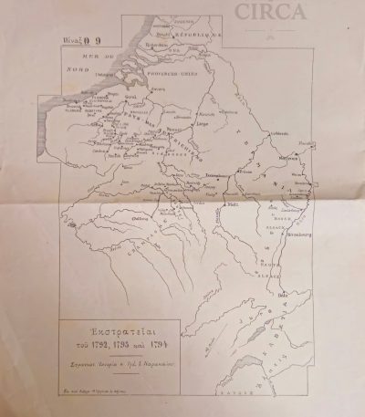
Filter by price
Stock status
Showing 1–12 of 33 results
1955’s Shell Road Map Greece – Athens to Corfu Route – Puzol Geoinstitute
€35.00Original Vintage Road Map (mid-1950s)
Road map covering the route Athens – Corfu, issued for Shell by the Geometric Institute of Greece (Puzol). Features a mid-century graphic layout, stylized island forms, Shell branding, and tables for fuel and distance conversions (Imperial, U.S. gallons and liters, including reference to the traditional Greek unit “oka”).
Make an Offer
1960s Tourist Map of the Dodecanese Islands – Greece – Rhodes Kos Karpathos
€20.00Original vintage tourist map of the Dodecanese Islands (Greece), likely printed in the 1960s.
The map shows the islands of Rhodes, Kos, Karpathos, Kalymnos, Patmos, Symi and many smaller islands, with roads, ports, beaches, monuments, monasteries, and tourist routes marked.
Includes printed travel notes and suggested excursions on the left panel.
Make an Offer
1966 Topographic Map of Pangaion & Kara Bair by P.F. Schenck (Greece) 1:100000
€45.00Topographic Map of Mount Pangaion (Western Section) and Kara Bair
Drawn by P.F. Schenck, dated 1966.
Printed with contour lines showing the relief of the Pangaion mountain range, including locations such as Platanotopos, Moustheni, Mesoropi, Podohori, Kokkinohori, Eleftheroupoli, and surrounding terrain.
This is a non-commercial topographic sheet, likely produced for academic, geological, or military survey purposes rather than general circulation.
Scale: 1:100,000 (noted in pencil at lower margin).
Language: German (Topographische Karte).
30 x 22 cm
Make an Offer
19th Century Greek Map of Attica & Euboea – Voyage of Anacharsis, Plate 10 (c.1830–1855)
€72.00Original 19th century engraved map of Attica and the island of Euboea, issued as Plate 10 from the Greek edition of the celebrated philhellenic work Voyage du jeune Anacharsis en Grèce by Jean-Jacques Barthélemy.
The map illustrates the geography of ancient Greece “according to the travels of Anacharsis,” one of the most influential Enlightenment publications on classical Greek history, widely used in European scholarship and Greek education during the early years of the modern Greek state.
Printed in Greek with period typographic style, the map shows Attica, Euboea and surrounding regions with classical place names, relief shading and multiple historical distance scales, including ancient Greek stadia and French leagues. Such maps were produced for scholarly and educational purposes and reflect early Greek historical geography and philhellenic scholarship.
Likely printed between circa 1830 and 1855.
Plate: Π. 10 (Plate 10)
30 x 22 cm
Condition:
Shows significant age wear, staining, foxing, and losses to margins, consistent with age and use. Surface wear and paper losses visible. Please review all photographs carefully.
Make an Offer
20th Century Folding Map of Bern Switzerland – Kümmerly & Frey Topographic City Plan (c.1930’s)
€45.00Original early 20th-century folding topographic map of Bern, Switzerland, depicting the city and its surrounding areas in fine cartographic detail.
Published by Kümmerly & Frey, Bern, one of the most respected Swiss cartographic publishers, the map presents a highly detailed city plan including streets, rivers, urban development, and surrounding landscapes.
Dimensions: approx. 45 × 36 cm
Good vintage condition consistent with age.
-
Typical fold lines from original use
-
Light wear and minor handling marks
-
Paper well preserved overall
Please review all photos carefully.
Make an Offer
Ankara Tourist Brochure with City Map – Ministry of Press, Radio, and Tourism (Turkey, c. 1955–1965)
€28.00Original vintage tourist brochure of Ankara, published by the Ministère de la Presse, de la Radiodiffusion et du Tourisme (Basin-Yayın ve Turizm Bakanlığı).
The cover features a color view of Anıtkabir, the Mausoleum of Mustafa Kemal Atatürk, completed in 1953. Inside includes a detailed map of Ankara and practical travel information in French, describing routes by bus, train, and airplane from Izmir, Iskenderun, and Erzurum.
Make an Offer
Antique Copper Engraved Chart – *Plan de Civitavecchia* (ca. 1700–1720)
€80.00Authentic French copperplate nautical chart of the fortified harbor of Civitavecchia. Richly detailed with forts, castle, depth soundings, and nautical bearings, with original scale in toises. Plate-mark clearly visible. An excellent example of early 18th-century maritime cartography.
Make an Offer
Antique geographical map of Armenia by Thomas Duvotenay (19th century).
€35.00Original 19th-century engraved map of Armenia and the Caucasus region, after the cartographer Thomas Duvotenay.
The map shows Eastern Anatolia, Armenia, Georgia, Northern Mesopotamia, and parts of Persia, including Tiflis (Tbilisi), Erzerum, Van, Mush, Mosul, Diyarbakir, and Lake Urmia.
28 x 21 cm
Make an Offer
Antique Nautical Chart – Spalatro (Split, Croatia), ca. 1700–1730
€85.00A rare copper-engraved French map of the fortified port of Spalatro (modern-day Split), from Plate 86 of an 18th-century maritime atlas. Features Fort Griffe (in inset), defensive walls, depth soundings in brasses and pieds, and a detailed compass rose.
Make an Offer
Antique Nautical Copper Engraving – *Plan du Port de Gênes* (ca. 1700–1725)
€80.00A rare copper-engraved map depicting the fortified port of Genoa (Gênes), finely detailed in French. Features military bastions, the royal gate, arsenal, docks, and soundings in feet and fathoms (*pieds*, *brasses*). The elegant compass rose and labeled forts add historical and artistic value.
Make an Offer
Battle of Jena 1806 – Greek Military Training Map (Early 20th c.)
€65.00Battle of Jena (14 October 1806)
Large military topographic map, printed with troop movements in red (French) and blue (Prussian & Saxon).
Greek military edition, likely used for officer training in tactical studies during the late 19th or early 20th century.
Labeled “Πίναξ 18” (Table 18), indicating its origin from a professional military Atlas of Campaigns of the Napoleonic Wars.
22 x 29 cm
Make an Offer
Cyprus EOKA Struggle Historical Map c.1960 – Museum of the National Struggle
€88.00Original Greek historical map of Cyprus, published by the Museum of the National Struggle (Μουσείο Αγώνος), documenting key locations and events of the EOKA struggle (1955–1959).
This map is a post-struggle commemorative and educational issue, produced shortly after the end of the conflict, and features a detailed illustrated legend marking:
-
execution sites (gallows)
-
detention and concentration camps
-
places of torture
-
armed clashes and bombings
-
locations of casualties and major incidents
Details:
-
Greek language
-
Offset-printed map
-
Large format: 61 × 43.5 cm
-
Issued folded, as originally distributed
-
Inscribed: “Εκδόσεις Μουσείου Αγώνος Αρ. 1”
Make an Offer
Online store with a wide selection of furniture and decor
Furniture is an invariable attribute of any room. It is they who give it the right atmosphere, making the space cozy and comfortable, creating favorable conditions for productive work or helping to relax after a hard day. More and more often, customers want to place an order in an online store, when you can sit down at the computer in your free time, arrange the furniture in the photo and calmly buy the furniture you like. The online store has a large catalog of furniture: both home and office furniture are available.
Furniture production is a modern form of art
Furniture manufacturers, as well as manufacturers of other home goods, are full of amazing offers: we often come across both standard mass-produced products and unique creations - furniture from professional craftsmen, which will be appreciated by true connoisseurs of beauty. We have selected for you the best models from modern craftsmen who managed to ingeniously combine elegance, quality and practicality in each product unit. Our assortment includes products from proven companies. Who for many years of continuous joint work did not give reason to doubt their reliability and honesty. All of them guarantee the high quality of their products, excellent operational characteristics, attractive appearance of the products, a long period of use of the furniture, as well as safety.