
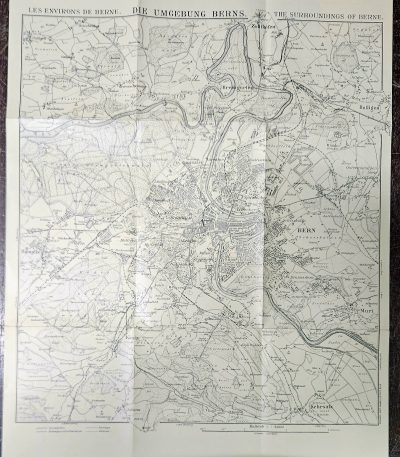
20th Century Folding Map of Bern Switzerland Kümmerly & Frey Topographic City Plan c 1930s
€28.00Original early 20th-century folding topographic map of Bern, Switzerland, depicting the city and its surrounding areas in fine cartographic detail.
Published by Kümmerly & Frey, Bern, one of the most respected Swiss cartographic publishers, the map presents a highly detailed city plan including streets, rivers, urban development, and surrounding landscapes.
Dimensions: approx. 45 × 36 cm
Good vintage condition consistent with age.
-
Typical fold lines from original use
-
Light wear and minor handling marks
-
Paper well preserved overall
Please review all photos carefully.
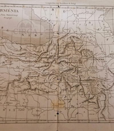
Antique geographical map of Armenia by Thomas Duvotenay (19th century).
€35.00Original 19th-century engraved map of Armenia and the Caucasus region, after the cartographer Thomas Duvotenay.
The map shows Eastern Anatolia, Armenia, Georgia, Northern Mesopotamia, and parts of Persia, including Tiflis (Tbilisi), Erzerum, Van, Mush, Mosul, Diyarbakir, and Lake Urmia.
28 x 21 cm
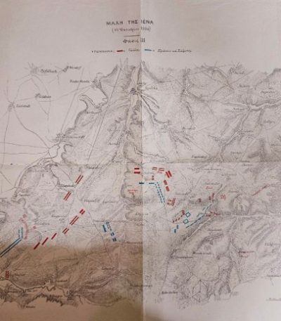
Battle of Jena 1806 – Greek Military Training Map (Early 20th c.)
€65.00Battle of Jena (14 October 1806)
Large military topographic map, printed with troop movements in red (French) and blue (Prussian & Saxon).
Greek military edition, likely used for officer training in tactical studies during the late 19th or early 20th century.
Labeled “Πίναξ 18” (Table 18), indicating its origin from a professional military Atlas of Campaigns of the Napoleonic Wars.
22 x 29 cm
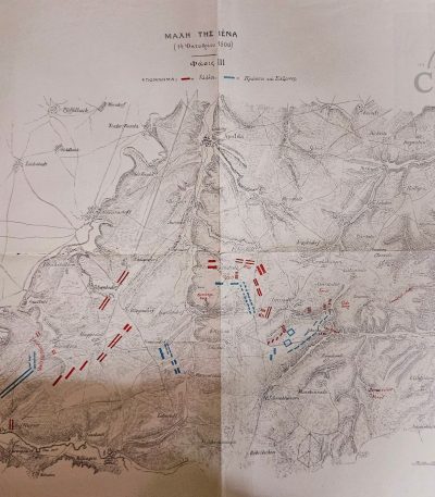
Battle of Jena 1806 – Later Greek Military Study Map (19th–Early 20th c.)
€35.00Original historical military map depicting the Battle of Jena (14 October 1806), one of the key engagements of the Napoleonic Wars.
Important note:
This is a later historical reproduction / study map, produced in the late 19th to early 20th century.
The map is presented in Greek language, likely originating from a military or academic publication, possibly associated with the Hellenic Military Academy (Evelpidon School) or a similar instructional manual of the period.
It illustrates troop movements and battlefield formations with colored markings, distinguishing:
French forces
Prussian and Saxon forces
The map shows:
- Fold lines throughout
- Minor edge wear and small tears
- Light toning and age-related discoloration
The map remains complete, stable, and fully legible, with strong visual impact.
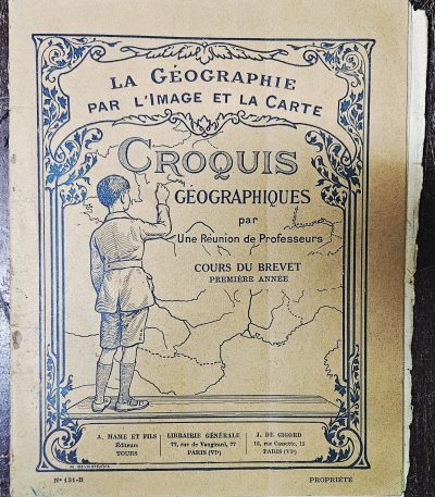
Croquis Géographiques – Cours du Brevet (Première Année) – Vintage French Geography Workbook with Maps, c.1930s
€12.00Original French educational geography workbook titled “Croquis Géographiques – Cours du Brevet, Première Année”, part of the series La Géographie par l’image et la carte, published in France in the early 20th century (circa 1930s).
-
Publishers: A. Mame et Fils (Tours) / Librairie Générale, Paris VIe / J. de Gigord, Paris VIe
-
Country: France
-
Date: circa 1930s
-
Pages: approx. 36
-
Dimensions: approx. 20 × 25 cm
-
Softcover illustrated wrapper
Condition
Fair / acceptable condition consistent with age and school use.
-
Fragile binding with wear
-
Some pages loose or partially detached
-
Creases, edge wear, staining and toning
-
Period handwritten notes and coloring throughout
-
Pages appear complete, but binding integrity is compromised
Please review photos carefully.

London Map – With the Compliments of The Dorchester – Vintage Folding Tourist Map, London 1975
€18.00Original vintage folding tourist map of London issued by the British Tourist Authority in association with the London Tourist Board, specially produced for guests of the famous The Dorchester hotel.
Dated circa 1975.
A London travel ephemera from the golden age of British tourism, featuring detailed central London street maps, Underground information, sightseeing guides, transport references, and iconic London imagery.
The colorful cover design includes:
- London Underground symbol
- Red double-decker bus
- Sherlock Holmes commemorative plaque
- Great Scotland Yard sign
- Theatre ticket graphic
- British tourist imagery
Contents include:
- Folding central London street map
- Around London transport map
- Underground references
- Tourist information and sightseeing guide
- Hotels, transport, and embassy information
- Places of interest in London
- British Tourist Authority publication details
Published by:
British Tourist Authority
64 St. James’s Street, London SW1
Printed by:
Cartographic Services (Cirencester) Ltd.
Folded size:
Approx. 10.5 × 20 cm
Condition:
Fair vintage condition with age wear, fold wear, light handling marks, and pencil annotations on the cover. Complete and visually attractive overall.
Vintage London Map 1975 – Αναδιπλούμενος Τουριστικός Χάρτης Λονδίνου από το The Dorchester
Αυθεντικός αναδιπλούμενος τουριστικός χάρτης του Λονδίνου, περίπου 1975, εκδομένος από τη British Tourist Authority για το διάσημο ξενοδοχείο The Dorchester. Περιλαμβάνει χάρτη κεντρικού Λονδίνου, πληροφορίες μεταφορών και London Underground, καθώς και χαρακτηριστική 1970s βρετανική τουριστική αισθητική.
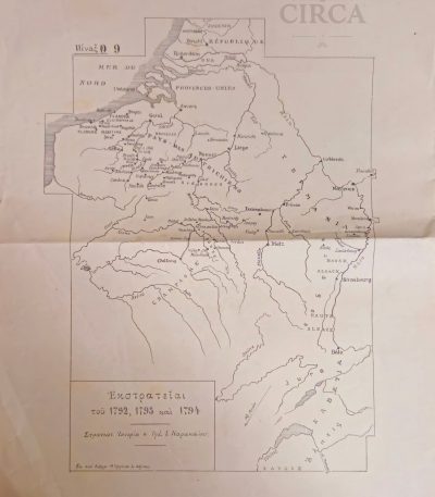
Map of French Revolutionary Campaigns 1792–1794 Greece Printed Military c.1910
€45.00Original printed historical map titled “Εκστρατείαι του 1792, 1793 και 1794”, showing military campaigns during the French Revolutionary Wars in Central Europe (Flanders – Rhine – Alsace – Luxembourg – Northern France).
The map is printed in Greek, likely from a military or educational historical atlas, attributed to Στρατιωτική Ιστορία, Τμήμ. Ι. Καρακάλος. c.1910
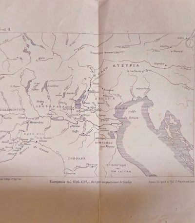
Napoleonic Italian Campaign Map 1796-1797 / Greek Edition c.1910
€45.00Original early 20th century printed map showing the Campaign of Napoleon Bonaparte in Italy (1796–1797).
Greek edition, used in historical and military studies in Greece by I. Karakalos, circa 1905–1915.
This map illustrates major strategic movements and geographical areas during the Italian campaign of the French Revolutionary Wars.
Printed on thin paper, folded as issued.
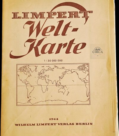
Original 1944 German World Map – Limpert Welt-Karte – Wilhelm Limpert Verlag Berlin – WWII Era Folding Map
€80.00Large original German world map issued in Berlin during World War II in 1944 by Wilhelm Limpert Verlag.
Titled “Limpert Welt-Karte”, this impressive folding educational map depicts the political world geography of the wartime period at a scale of 1:30,000,000. Printed during the final phase of WWII, the map preserves the geopolitical boundaries and country names of the era.
Originally intended for educational or classroom use, the map folds into its original paper cover and opens to a large display format.
Details:
- Publisher: Wilhelm Limpert Verlag, Berlin
- Date: 1944
- Title: Limpert Welt-Karte
- Scale: 1:30,000,000
- Size (opened): approx. 120 × 80 cm
- Folding paper map
- German language
Condition:
Good vintage condition overall with age wear, a small cut, fold lines, creasing and toning from use and storage. No major visual loss when displayed. Please see photographs carefully for exact condition details.
Μεγάλος Γερμανικός Παγκόσμιος Χάρτης 1944 – Limpert Welt-Karte Β΄ Παγκοσμίου Πολέμου
Αυθεντικός μεγάλος γερμανικός παγκόσμιος χάρτης του 1944 από τον εκδοτικό οίκο Wilhelm Limpert Verlag Berlin. Εκδόθηκε κατά τη διάρκεια του Β΄ Παγκοσμίου Πολέμου και παρουσιάζει την παγκόσμια γεωγραφία και τα σύνορα της εποχής. Αναδιπλούμενος χάρτης μεγάλου μεγέθους (120 × 80 εκ.)
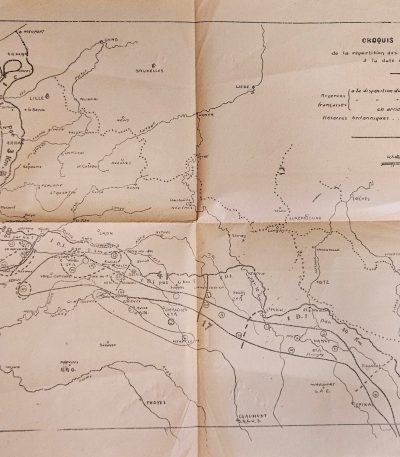
Post-WWI Military Training Map – French Western Front Allied Positions 26 May 1918 Instruction Map
€25.00French military instructional map showing the Allied force dispositions on the Western Front as of 26 May 1918.
Although the map depicts a wartime situation, the printing style and simplified schematic layout indicate that it was produced post-war (likely 1920–1938) for staff training or military history instruction, rather than for active battlefield use.
Μεταπολεμικός γαλλικός στρατιωτικός εκπαιδευτικός χάρτης, που απεικονίζει τις θέσεις των Συμμαχικών δυνάμεων στο Δυτικό Μέτωπο στις 26 Μαΐου 1918. Παρότι αφορά γεγονότα του Α’ Παγκοσμίου Πολέμου, πρόκειται για μεταγενέστερη έκδοση (περ. 1920–1938), που χρησιμοποιήθηκε για στρατιωτική εκπαίδευση και ανάλυση επιχειρήσεων, και όχι για άμεση πολεμική χρήση.
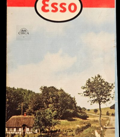
Vintage Esso Denmark Road Map – DANMARK / DENMARK – Folding Touring Map, 1958
€16.00Original vintage Esso road map of Denmark issued by Dansk Esso A/S, Copenhagen, featuring detailed road networks, ferry routes, city indexes, and touring information.
Title:
DANMARK – DENMARK
Published by:
Dansk Esso A/S, Copenhagen
Updated:
October 1958 (“Ajourført Oktober 1958”)
The map was prepared using designs by the renowned American cartographic company:
General Drafting Co., Inc., New Jersey, U.S.A.
Features:
- Large folding road map of Denmark
- Original Esso petroleum branding
- Detailed highway and ferry connections
- City and town index
- Bilingual Danish / English legend
- North Zealand inset map
- Bornholm inset map
- Mid-century travel and motoring aesthetic
Folded size:
Approx. 10.5 × 20 cm
Condition:
Good vintage condition with age wear, fold wear, light edge wear, and minor handling marks consistent with use. Presents very well overall.
Vintage Χάρτης Δανίας ESSO 1958 – Αναδιπλούμενος Οδικός Τουριστικός Χάρτης DANMARK
Αυθεντικός αναδιπλούμενος οδικός χάρτης της Δανίας από την ESSO, έκδοσης 1958, από την Dansk Esso A/S Κοπεγχάγης. Περιλαμβάνει αναλυτικό οδικό δίκτυο, ακτοπλοϊκές συνδέσεις, πίνακες πόλεων.
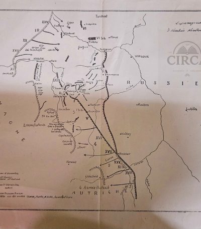
WW1 Armistice Map (Positions 11 Nov 1918) – Later Staff Printing (c.1930s)
€55.00Original military instructional map showing the positions of German, French and Austro-Hungarian armies on 11 November 1918 (day of the Armistice).
This is a later Greek military staff printing (c. 1920s–1930s) used for officer training in strategic operations.
40 x 32 cm