
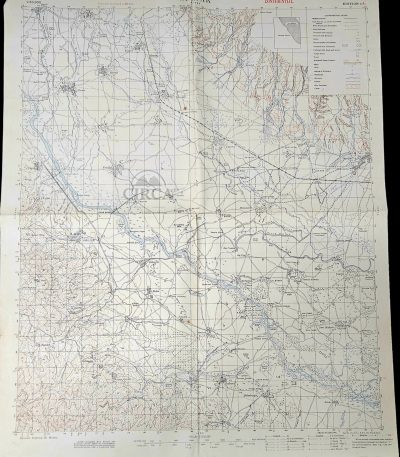
1917 WWI British Trench Map Orljak Rupel Pass Macedonian Front Confidential Military Map
€185.00Original British World War I military topographical map of the Orljak–Rupel Pass region, issued in 1917 and marked “CONFIDENTIAL”.
This detailed field map covers a strategically important sector of the Macedonian Front in the Balkans, produced for operational military use. It includes extensive terrain information, infrastructure, and marked trench systems.
The sheet explicitly states “Trenches corrected to 20-11-17”, allowing precise dating to late 1917. The map was compiled from ground surveys and aeroplane photographs — a characteristic method of WWI military cartography.
Printed in colour lithography with contour lines, waterways, roads, bridges, and military positions. A genuine wartime military document, not a modern reproduction.
Details
-
Title: ORLJAK – RUPEL
-
Date: 1917 (World War I)
-
Edition: Edition 1A
-
Classification: Confidential
-
Scale: 1 : 50,000
-
Contour interval: 20 metres
-
Origin: United Kingdom
-
Technique: Colour lithographic military printing
-
Dimensions: approx. 50 × 63 cm
Condition
Good overall vintage condition for a WWI field map. Original folds from use, light wear, minor edge handling and age toning. No restoration.
Χάρτης ORLJAK – RUPEL – Βρετανικός Στρατιωτικός Χάρτης Α΄ Παγκοσμίου Πολέμου, 1917
Αυθεντικός βρετανικός στρατιωτικός χάρτης του 1917 που απεικονίζει το μέτωπο της Μακεδονίας στην περιοχή Ορλιάκ–Ρούπελ, με λεπτομερή αποτύπωση χαρακωμάτων, εδάφους και στρατιωτικών θέσεων.
1955’s Shell Road Map Greece – Athens to Corfu Route – Puzol Geoinstitute
€35.00Original Vintage Road Map (mid-1950s)
Road map covering the route Athens – Corfu, issued for Shell by the Geometric Institute of Greece (Puzol). Features a mid-century graphic layout, stylized island forms, Shell branding, and tables for fuel and distance conversions (Imperial, U.S. gallons and liters, including reference to the traditional Greek unit “oka”).
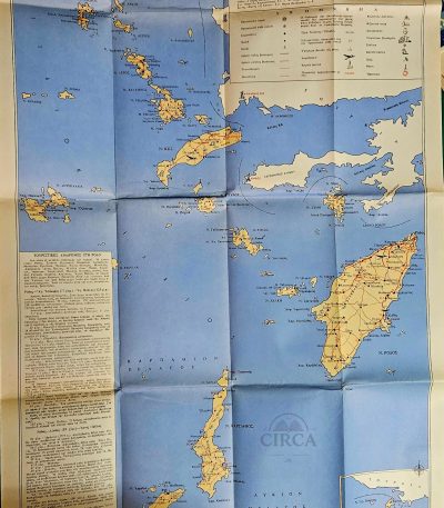
1960s Tourist Map of the Dodecanese Islands – Greece – Rhodes Kos Karpathos
€18.00Original vintage tourist map of the Dodecanese Islands (Greece), likely printed in the 1960s.
The map shows the islands of Rhodes, Kos, Karpathos, Kalymnos, Patmos, Symi and many smaller islands, with roads, ports, beaches, monuments, monasteries, and tourist routes marked.
Includes printed travel notes and suggested excursions on the left panel.
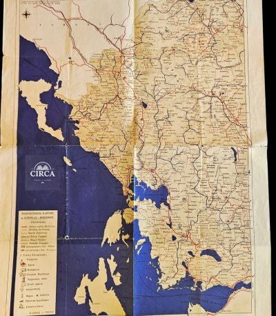
1965 Greek Tourist Road Map – Western Central Greece & Epirus – Vintage Folding Map
€25.00Original vintage Greek folding tourist road map titled:
“ΤΟΥΡΙΣΤΙΚΟΣ ΟΔΗΓΟΣ 1965”
(“Tourist Guide 1965”)
A beautifully designed mid-century Greek travel map covering:
- Western Central Greece (Sterea Ellada)
- Epirus
- Ionian coastal regions
- Gulf of Patras area
Printed in Greece, the map presents:
- the period road network,
- mountain routes,
- ports,
- archaeological sites,
- airports,
- camping areas,
- lighthouses,
- spa towns,
- and tourist landmarks.
Condition:
Good vintage condition with fold wear, creasing and age toning consistent with age. Please examine photographs carefully.
Details:
Greece
1965
Folding tourist road map
Greek language
Approx. 43 x 58 cm unfolded
Scale: 1:500.000
Τουριστικός Οδικός Χάρτης Ελλάδας 1965 – Δυτική Στερεά Ελλάδα & Ήπειρος
Αυθεντικός ελληνικός αναδιπλούμενος τουριστικός χάρτης του 1965, που απεικονίζει τη Δυτική Στερεά Ελλάδα, την Ήπειρο και τις παράκτιες περιοχές του Ιονίου.
Περιλαμβάνει το οδικό δίκτυο της εποχής, πόλεις, λιμάνια, αρχαιολογικούς χώρους, αεροδρόμια, λουτροπόλεις και τουριστικά σημεία ενδιαφέροντος.
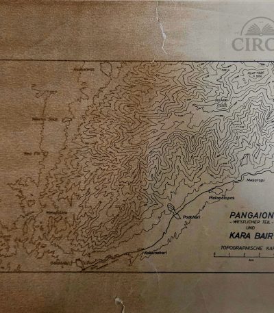
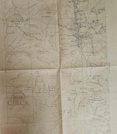
1966 Topographic Map of Pangaion & Kara Bair by P.F. Schenck (Greece) 1:100000
€45.00Topographic Map of Mount Pangaion (Western Section) and Kara Bair
Drawn by P.F. Schenck, dated 1966.
Printed with contour lines showing the relief of the Pangaion mountain range, including locations such as Platanotopos, Moustheni, Mesoropi, Podohori, Kokkinohori, Eleftheroupoli, and surrounding terrain.
This is a non-commercial topographic sheet, likely produced for academic, geological, or military survey purposes rather than general circulation.
Scale: 1:100,000 (noted in pencil at lower margin).
Language: German (Topographische Karte).
30 x 22 cm
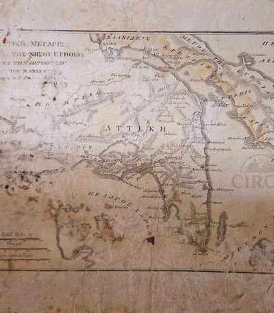
19th Century Greek Map of Attica & Euboea – Voyage of Anacharsis, Plate 10 (c.1830–1855)
€72.00Original 19th century engraved map of Attica and the island of Euboea, issued as Plate 10 from the Greek edition of the celebrated philhellenic work Voyage du jeune Anacharsis en Grèce by Jean-Jacques Barthélemy.
The map illustrates the geography of ancient Greece “according to the travels of Anacharsis,” one of the most influential Enlightenment publications on classical Greek history, widely used in European scholarship and Greek education during the early years of the modern Greek state.
Printed in Greek with period typographic style, the map shows Attica, Euboea and surrounding regions with classical place names, relief shading and multiple historical distance scales, including ancient Greek stadia and French leagues. Such maps were produced for scholarly and educational purposes and reflect early Greek historical geography and philhellenic scholarship.
Likely printed between circa 1830 and 1855.
Plate: Π. 10 (Plate 10)
30 x 22 cm
Condition:
Shows significant age wear, staining, foxing, and losses to margins, consistent with age and use. Surface wear and paper losses visible. Please review all photographs carefully.
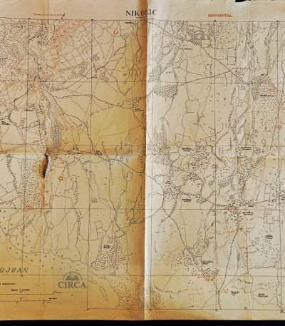
British WWI Confidential Trench Map of Lake Doiran / Nikolic Sector – Macedonia Front 1918
€75.00Rare original British military trench map from the First World War, covering the Lake Doiran (Dojran) sector of the Macedonian / Salonika Front.
Marked “CONFIDENTIAL” and titled “NIKOLIC”, this detailed operational map includes trench systems, fortified positions, machine gun emplacements, redoubts, roads, waterways and military annotations. The map notes:
“Trenches corrected to 10-8-18”
indicating updates made during the final months of WWI operations in the Balkans.
The Doiran sector was one of the most important battle zones of the Macedonian Front, where British, Greek and Allied forces fought against Bulgarian defensive lines during 1917–1918.
Approx. size: 63 × 51 cm
Condition:
Heavily worn with folds, edge wear, toning, creasing and a significant tear/hole near the central fold area.
A rare original WWI military cartographic document from the Balkan / Salonika campaign.
Βρετανικός Στρατιωτικός Χάρτης Χαρακωμάτων Α’ ΠΠ 1918 – Δοϊράνη / Μακεδονικό Μέτωπο
Σπάνιος αυθεντικός βρετανικός στρατιωτικός χάρτης χαρακωμάτων του Α’ Παγκοσμίου Πολέμου από το μέτωπο της Δοϊράνης. Με ένδειξη “CONFIDENTIAL”, ενημερωμένος έως 10-8-1918, με χαρακώματα, οχυρώσεις και στρατιωτικές σημειώσεις. Ιστορικό κομμάτι του Μακεδονικού Μετώπου.
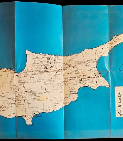
Cyprus EOKA Struggle Historical Map c.1960 – Museum of the National Struggle Nicosia, Greek Military & Political Ephemera
€55.00Original Greek historical map of Cyprus, published by the Museum of the National Struggle (Μουσείο Αγώνος), documenting key locations and events of the EOKA struggle (1955–1959).
This map is a post-struggle commemorative and educational issue, produced shortly after the end of the conflict, and features a detailed illustrated legend marking:
-
execution sites (gallows)
-
detention and concentration camps
-
places of torture
-
armed clashes and bombings
-
locations of casualties and major incidents
Details:
Greek language
Offset-printed map
Large format: 61 × 43.5 cm
Issued folded, as originally distributed
Inscribed: “Εκδόσεις Μουσείου Αγώνος Αρ. 1”
Αυθεντικός ιστορικός χάρτης της Κύπρου για τον αγώνα της ΕΟΚΑ (1955–1959), έκδοση του Μουσείου Αγώνος στη Λευκωσία, περίπου το 1960. Περιλαμβάνει αναλυτική καταγραφή τόπων εκτελέσεων, στρατοπέδων κράτησης, συγκρούσεων και σημαντικών γεγονότων.
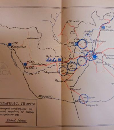
Greek Army Staff Atlas (31 Maps) First Balkan War Operations c.1916–1920 Rare
€125.00Rare original Greek Army Staff Atlas containing 31 detailed military operational maps
from the First Balkan War (1912–1913). Printed shortly after the war, around 1916–1920, probably
for internal officer training and General Staff study purposes. Unfortunately, the Maps with Number 1 , 4 and 19 are missing. The last map is detached but present.
If you need better photos or more information, please feel free to ask.
Greek Military Topographic Map “Strumnitsa – Gevgeli” 1928 – GYS Army Map
€58.00Original Greek military topographic map titled “Strumnitsa – Gevgeli”, issued by the Geographical Service of the Hellenic Army (GYS), dated 1928.
This detailed map covers the wider region of Strumnitsa and Gevgeli (today North Macedonia / Northern Greece border area), an area of significant strategic importance during the interwar period.
Printed at a scale of 1:100,000, the map presents extensive topographical information including terrain, rivers, settlements, and infrastructure. Notably, the map also bears period hand-drawn markings and annotations in colored pencil, likely of military or operational nature.
Overall worn condition, consistent with age and use.
The map shows:
Visible fold lines throughout
Multiple tears and edge wear
Creasing and handling marks
Age toning and discoloration
Signs of prolonged use in the field
Despite its condition, the map remains complete and fully legible, and retains strong historical and display value.
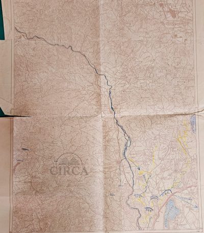
WW1 Map “Serka di Légen” – Armée d’Orient – June 1918 – Original French Military
€75.00Original French WW1 Military Topographic Map – “Serka di Légen”, dated June 1918.
Issued by the 122e Section Topographique Divisionnaire (marked S.T.D. 122e) of the Armée d’Orient on the Macedonian Front.
48 x 65 cm
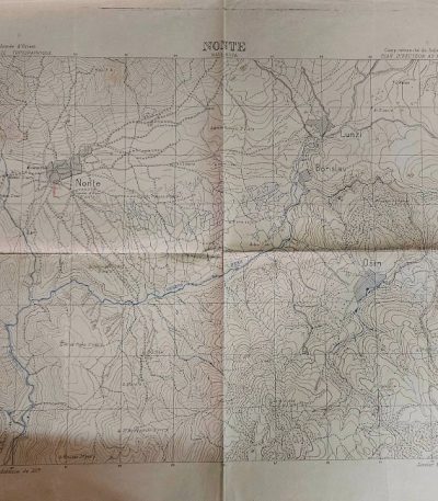
WWI Military Map Salonika Front Nonte Mala Rupa Armée d’Orient (Jan 1917)
€75.00Original WWI Military Topographic Map of the Salonika Front – Nonte (Mala Rupa) area, issued by the Armée d’Orient, Service Topographique, January 1917.
Scale 1:20,000. Detailed elevation contours, rivers, villages, and marked terrain features used for operational planning during the Macedonian Campaign (1916–1918).
60 x 55 cm